Bathymetric Survey
To build a hydrodynamic computer
simulation model the most
important input data set
is the spatial depth distribution with in the model area,
the bathymetry.
These information may be
gained from already existing
digital data sets, from an up-to-date bathymetric map or by
carrying
out a bathymetric survey.
Based on such data sets a
digital spatial model (depth/height grid describing the spatial
position)
will be produced. Finally
this spatial grid serves
as the computational grid for the simulation model.
To gain
good and recent information
about the spatial water depth distribution within the target
area it was decided to carry
out a new bathymetric
survey. Depth measurements were done with an echo sounder
which emits sonar signals in short time
intervals. The echo sounder
is calculating the actual water depth from the runtime of
the sonar signal from the transducer
to the reflecting sea
bottom back to the transducer and the known sound velocity
within the water body. The corresponding
position of the measured
water depth was gained from a DGPS (Differential Global Positioning
System) which was synchronised
with the echosounder.
The combination of these two data sets provided a three-dimensional
spatial digital model.
|
 |
Mounting
of the bathymetric measuring system on the survey boat
|
Applying some mathematical procedures the bathymetric data set
was modified to be in correspondence
with the rectangular and equidistant computational grid which is
the basis for the simulation
model.
|
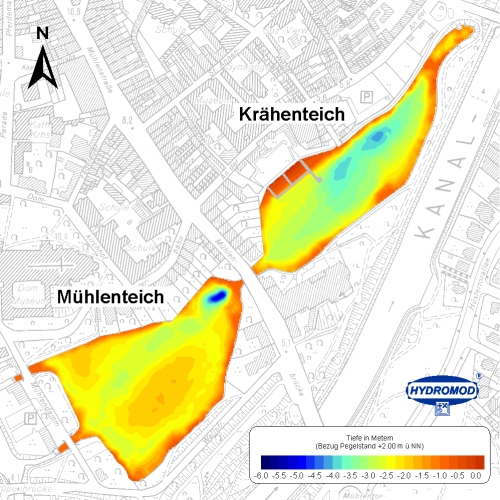
Recent
bathymetry of Mühlen- and Krähenteich
|
Apart from the production of the
bathymetric map the echo sounder
data may be used for further evaluation
which provide characteristic information
on the lake system. These information
may provide additional criteria
to analyse the model results.
|
|
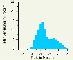
Depth
distribution in Mühlenteich |
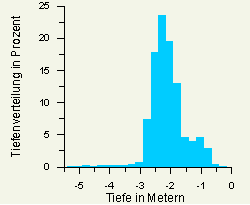
Depth distribution
in Krähenteich
|
next
...